Journey to the Not-Quite-Center of the Earth
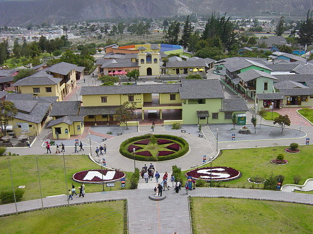
The image above comes from Pichincha, Ecuador, at a place called Ciudad Mitad del Mundo — literally, Middle of the World City. If you look carefully, you’ll see a yellow-ish line on the walkway at the bottom of the image. That line represents the Equator, making Ciudad Mitad del Mundo a nice little tourist trap where visitors can jump between the Northern and Southern Hemisphere much like Homer Simpson at the American Embassy in Australia. It makes a lot of sense that such an attraction exists; after all, Ecuador translates to “Republic of the Equator,” so there’s an understandable affinity there for the invisible line that runs through the South American nation. And Cuidad Mitad del Mundo is a very nice homage to the geographically unique place upon where it lives. There are well manicured lawns, pristine walkways, and a handful of statues and monuments, too. It’s nearly perfect, given what it is.
Except that it’s not actually on the Equator.
The error dates back to the late 1730s, when French king Louis XV sent an expedition to Ecuador to determine whether the circumference of the Earth was greater around the planet’s center or around its poles. The mission ultimately concluded, by 1739, that the Earth is shaped the way we now know it to be, using a series of astronomical data sets to draw this conclusion. But the measurements weren’t as accurate as modern technology allows. Unfortunately, when Ecuador built the monument and park in 1936 (in honor of the expedition’s 200th anniversary, even though the expedition itself likely never went through what is now Pichincha), they used the only data they had — the 200 year-old one, which is unfortunately, off by a little bit.
No one knew it at the time, though. As Google Maps and the like developed, the world realized that the measurement tools of 1736 were good, but not perfect. The yellow line above is about 250 yards (225 meters) from the actual Equator, resulting in a lot of vacation photos which are geographically wrong and a big monument which is similarly in the incorrect spot. Fixing it isn’t really possible — at least not within a reasonable budget — so instead, a nearby institution, the Intiñan Museum, capitalized on the opportunity and created the work-around pictured below.
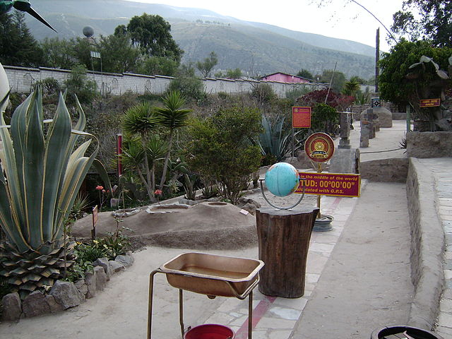
The red line is the true Equator, running through a staircase (The staircase was there before the powers that be realized the error. And why ruin a perfectly good staircase on behalf of an invisible line?)
As one visitor’s report notes, you’ll still see signs saying that you’re at 0°00′00″ at Ciudad Mitre del Mundo, though, a claim echoed by the museum’s website even though we all know that’s not true. And more importantly, tourists agencies and the like still push visitors to visit that museum, calling it the true home to the Equator, even though it’s not. One of the reasons for this may be the relative campiness of the activities at the red line; that same report claims that the Intiñan Museum offers the opportunity to do “all sorts of magical equator-like things such as balancing an egg on the head of a nail, and falling over sideways as you attempt to walk the line with your eyes closed,” without the picturesque background of its incorrect neighbor a short distance away. But at least it’s in the right place!
Bonus Fact: As the top graph here shows, more than 85% of the Earth’s population lives in the Northern Hemisphere.
From the Archives: Dr. Scholl’s Path to the Presidency: An unlikely candidate for a small town election in Ecuador.
Related: “Following the Equator: A Journey Around the World” by Mark Twain. Free on Kindle.