Scrambled City
Medieval Europe lent itself to odd rules, especially when it came to those which governed the title and transfer of land. Dukes and lords would treat tracts of land, small and huge alike, as currency, trading them for produce, textiles, and in some cases, peace from other warring factions. Sometimes, the results are complicated. Other times, they can be downright comical.
The perfect example? Welcome to Baarle-Hertog, Belgium.
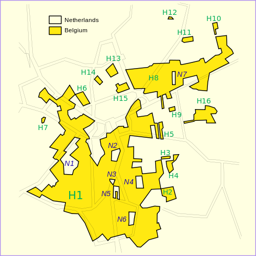
Located on the border of Belgium and the Netherlands, the main part of the municipality, called Zondereigen, is tucked neatly within the well-known and obvious borders of the nation. But travel about five miles northeast into the Netherlands and you’ll re-enter Baarle-Hertog, and, by extension, Belgium. And then you’ll leave it again, and re-enter, and leave it again, and re-enter, and…
Well, let’s just look at the map. All the yellow areas, below, are in Belgium; the rest is the Netherlands.

Some houses and business are divided between the two nations, which has lead to a bunch of oddities, such as residential buildings split in half (for example, seen here) and retail establishments with beer straddling the line between the two nations. Buildings pay taxes based on where their front doors are located, which has resulted in shops moving their doors as a tax dodge of sorts. At one point, Dutch laws required that restaurants close by a certain hour, so divided eateries would move patrons to the Belgian side of the shop to continue their meals. But all of these pale in comparison to the ridiculous scheme allegedly perpetrated by a bank in 1971.
According to Futility Closet, the bank in question was involved in laundering money, but was shielded from authorities due to the Baarle’s quirky geography. The entrance to the bank was in the Netherlands, which meant that only Dutch officials had legal authority to enter. But the bank’s safe was in Belgium — outside of the jurisdiction of the Dutch. The two nations ended up collaborating on a joint investigation to finally obtain the necessary evidence to defeat the crooked bank.
Bonus fact: The northernmost part of the contiguous 48 United States is the Northwest Angle, in Minnesota. But it is not truly contiguous with the rest of the main part of the nation; as seen in this map, to get there by land, one has to enter into Manitoba, Canada.
From the Archives: The Geopolitical Babushka Doll: A country inside a country inside a country.

Leave a comment