The Day That Never Happened
Where were you on December 30, 2011?
Can’t remember? Well, one thing’s for sure: you weren’t on the Oceanian islands of Samoa. You couldn’t have been, because no one was. There was no December 30, 2011 there.
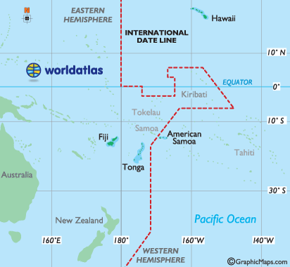
Samoa, in grey text in on the map above (via World Atlas), is one of the few points east of the 180th meridian but west of the International Date Line. Even though Samoa is incredibly close to American Samoa — they are less than 100 miles apart — when it’s Monday on Samoa, it’s still Sunday on American Samoa. But it wasn’t always that way. From the summer of 1892 until the end of 2011, Samoa was on the other side of the world, with its clocks showing the same date as the clocks in American Samoa.
But in June of 2011, Samoa (as well as the even tinier island nation of Tokelau to its north) decided to change sides. Samoa’s main trading partners, New Zealand and Australia, were on the other side of the International Date Line, and therefore, the island of about 185,000 people (plus another 2,000 or so on Tokelau) were out of sync with the external drivers of their economy. For example, Samoan Prime Minister Tuila’epa Sailele Malielegaoi told reporters that before the switch, Samoa was 23 hours behind Auckland and 21 hours behind Sydney, leading to odd problems in coordinating business needs: “while it’s Friday here, it’s Saturday in New Zealand, and when we’re at church on Sunday, they’re already conducting business in Sydney and Brisbane.”
The change went into effect just before midnight at the close of Thursday, December 29, 2011. When the clock struck twelve, the International Date Line moved, hopping to the other side of the islands. Friday, December 30, 2011, skipped over the island in the process; when December 29th ended, December 31st began, and Thursday led directly into Saturday. Despite the gap in the calendar, the change was rather seamless — countries around the International Date Line are allowed to move it to meet their needs, without the permission of others. (There’s no international law which sets forth the location of the line — it, like any other time zone demarcation, is drawn by aggregating local laws.) The government even made sure that workers who missed Friday’s work day were still paid as if Friday had happened.
Incredibly, if you lived long enough on Samoa, you would have come up even. Before 1892, Samoa was, like it is now, on the west side of the International Date Line. But during the late-1800s, Samoa’s main trade partners were located on the west coast of the United States, and the U.S convinced Samoa to jump to the American side of the line. That shift resulted in an extra day, not a lost one. What day did Samoa choose to live twice? As the New York Times reported, “[the 1892] shift took place on the American Independence Day — so the Samoans could celebrate July 4 twice.”
Bonus Fact: In the map above, you’ll note that the International Date Line takes a pretty dramatic bend into the Pacific to accommodate for the nation of Kiribati. Kiribati, in total, is about 1.3 million square miles, but that land area is spread across nearly three dozen different islands and atolls. (Here’s a map.) The dots of land to the south of Hawaii, known as the Line Islands, were originally on the other side of the International Date Line, effectively placing them 23 hours apart from the rest of the nation. Kiribati rezoned itself in 1995.
Take the Quiz: Name the most populous city in each time zone. This one was shockingly difficult.
From the Archives: Time Travel: Where did U.S. time zones come from?
Related: Samoas. (You probably know what’s behind that link.)