The Drones With Brains of Their Own

Ascension Island is located in the South Atlantic Ocean, about equidistant from the coast of Africa and Brazil. (Here’s a map.) If there’s a middle of nowhere, Ascension Island is pretty close to it, which makes it a really great place for scientific research — with fewer than 1,000 people on the island and literally no one else for miles, you can run all sorts of experiments without bothering too many people.
For climate scientists, that’s certainly the case. Take, for example, the work of Dr. Rick Thomas, a Senior Research Fellow at the School of Geography, Earth and Environmental Sciences at the University of Birmingham. Dr. Thomas focuses much of his research on the atmosphere, and, he explains here, that requires sending sensors into the sky. On Ascension Island, that’s pretty easy: he uses unmanned aerial vehicles, also known as UAVs or, colloquially, “drones.” As Dr. Thomas explains, drones are a great solution “in areas where it may be difficult or dangerous to use manned aircraft” — that is, places like Ascension Island.
But what about places with lots of people? In those situations, drones aren’t a great solution. Unauthorized aircraft of any size can be a threat to the people below and to any airplanes taking flight in the region, and authorities tend to play it safe. In 2019, for example, drone sightings resulted in a 90-minute shutdown of Newark Airport in New Jersey. And perhaps more famously, Gatwick Airport outside of London delayed approximately 1,000 flights in December of 2018 due to drone threats. While researchers could probably get permission to fly drones here and there, it’s probably not a great solution if you’re looking to gather a lot of data from a heavily populated area.
So when Dr. Thomas wanted to gather info from the skies above his hometown of Birmingham, England, he had to come up with another solution. Here it is, below.
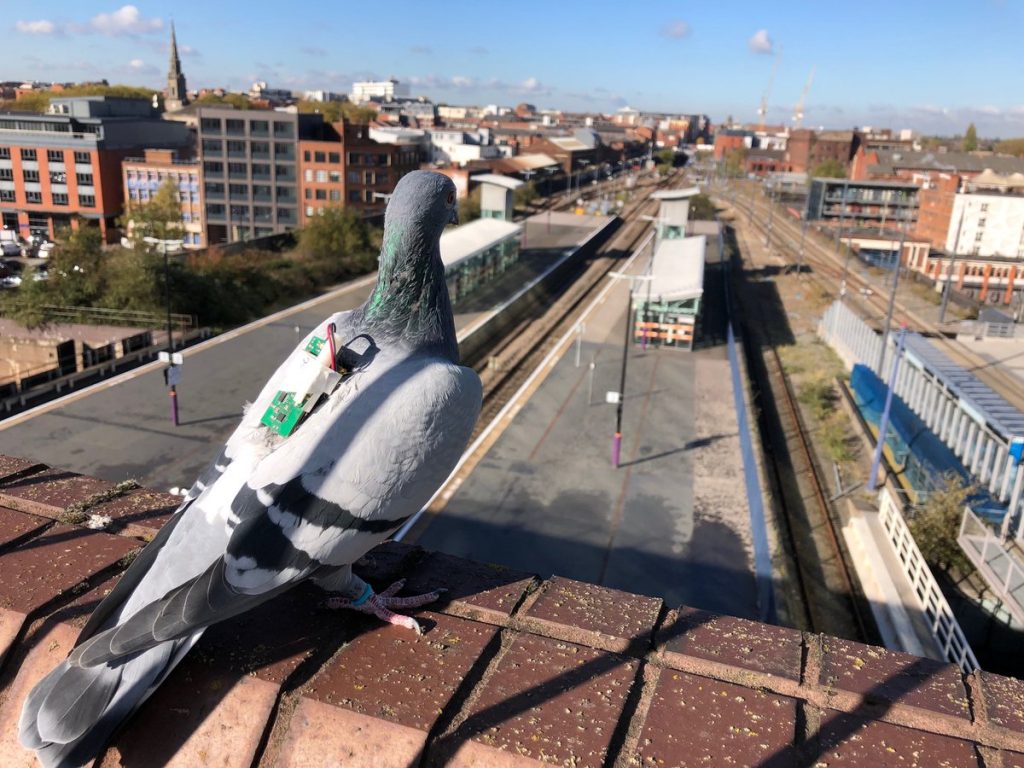
Yes, a pigeon. With a sensor strapped to its back.
As Thomas explained to Gizmodo, there are places you can’t find drones “but birds—they fly everywhere.” All you need to do is find the right ones. Thomas’s avian friends, according to an Australian magazine covering the energy sector, “are homing pigeons owned by local enthusiasts who have volunteered their prized pets for the important work.” The well-trained birds take to the skies carrying the sensor — which weighs less than 3% of their body weight — tracking the air temperature throughout. Here’s a video of one such flight path, with the temperatures superimposed.
As of about a year ago (per Gizmodo), the flying sensor squad has flown more than three dozen flights totaling more than 1,000 kilometers in distance. And the data they’ve collected have been used for long-term studies as well as short-term benefits. Per one report, the heat map developed by the bird data can “help with air pollution research;” specifically, “if we can discover where the major pollution ‘hotspots’ are, city planners can avoid building public spaces in these areas.”
And as a bonus, the data gathering team is unlikely to shut down any airports.
Bonus fact: If Dr. Thomas wanted to monitor the air over the All England Club (home of the Wimbledon tennis tournament), drones would probably be a better option than pigeons. Why? Because if they land near a tennis court, that could be a problem. For years, the All England Club has been patrolled by Rufus the Hawk, a hawk (as his name suggests). Rufus’s job, per the BBC, is “to keep an eye out for pigeons” and “to scare them off and stop them eating the grass.”
From the Archives: Project Pigeon: Pigeon-powered projectiles.