Google… Sheep View?
In February 2005, Google entered the world of driving (and walking) directions, releasing Google Maps. The product was met with widespread acclaim, even appearing in an SNL skit that December in which Andy Samberg and Chris Parnell rap their love of the product, noting that Yahoo! Maps and Mapquest are good, but proclaiming Google Maps as “the best.” Fast forward a year and a half, and Google Maps got even better. In May of 2007, the search giant introduced “Google Street View” into the mix, allowing users to see panoramic views of many streets and intersections around the globe.
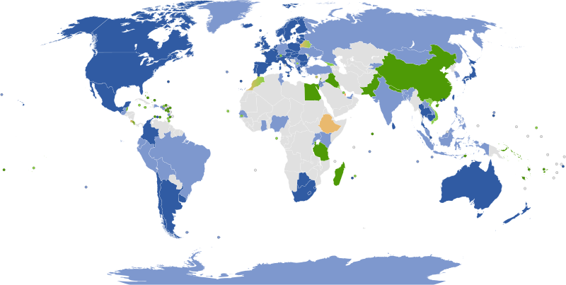
Today, Google’s coverage of many areas is comprehensive; you’ll find a Street View for almost everywhere in the countries and dependencies in dark blue, above. (The map is via Wikipedia, originally here.) To get those images, Google typically sends a special car, as seen here, to the areas it wants to map; the car is outfitted with a 360-degree camera that takes lots of pictures as the driver navigates their way throughout the neighborhood. For some parts of the world — like China (in green, which means that only tourist attractions are in the database) — political barriers prevent the Street View car from doing its magic; for others, like most of Africa, infrastructure is the limiting factor.
And then there are the Faroe Islands.
The Faroe Islands are an archipelago north-northwest of the British Isles and southeast of Iceland. There are 18 large islands which, collectively, are home to about 50,000 people, and as you can imagine, it’s rather rural — there are a lot of little villages and not a lot of roads connecting them. It’s not a place where the Street View car can easily go, and it’s also not a place that Google believes was a high priority for such mapping anyway. And that didn’t sit well with the islands’ tourism board. So they decided to take matters into their own hands — or, more accurately, onto the backs of some livestock.
The Faroe Islands are home to more sheep than people, with roughly 80,000 Faroese sheep running around the archipelago. And unlike most sheep, the Faroese breed roams independently; with no natural predators, they’ve either lost or never developed the pack mentality needed to protect one another. It’s not uncommon to see a half-dozen or fewer sheep galavanting around the rocky hills or shores of the island.
That provided the tourism board with the opportunity she needed to get the Street View data for Google — even though the Internet giant didn’t ask. Her solution is seen below, via the Washington Post.
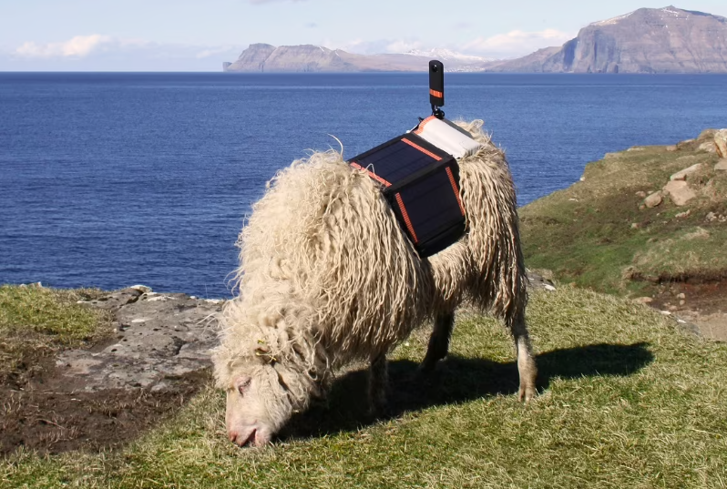
As the Post explains, the agency “knew that its rugged terrain would not be easily traversed by those Google cars that ply city streets worldwide, snapping photos. So it strapped solar-powered, 360-degree cameras onto the backs of a few shaggy Faroese sheep and began uploading the resulting, and very breathtaking, images to Street View itself.”
The idea worked. In July 2016, Durita Dahl Andreassen, an employee of the tourism board who engineered the harness, told the Guardian that “the Sheep View team [had] taken panoramic images of five locations on the island” and shared with them a one-minute, 19-second video of one of the sheep roaming the Faroe countryside, which you can watch here. The sheep captured some pretty great images and their corresponding latitude and longitude, and using that information, Andreassen was able to upload some panoramas to Google Street Views. And that caught the attention of the Google team.
The next month, Google announced on its blog that they were going to support the Faroe Island tourism board’s efforts. Calling the Sheep View project “shear brilliance” (that’s not a typo), Google “decided to help the Faroese by supplying them with a Street View trekker [basically, a backpack — for humans — with the camera equipment] and 360 cameras via [their] Street View camera loan program.” Using this equipment — with the assistance of some Google employees who went to the Islands to help — the tourism board was able to add many of its roads and points of interest to the Street View database.
And in the end, we’re all better off. Because of the sheep effort, those of us far from the Faroe Islands are now able to see some incredible sights, like this one.
Bonus fact: In the early 1990s, the population of the Faroe Islands began to dip for the first time in over a century. The cause, which continues today, is emigration, as the BBC reported in 2017: “in recent years the Faroes have experienced population decline, with young people leaving, often in search of education, and not returning.” And women have been more likely than men to leave permanently, leading to a gender gap — there are about 2,000 more men than women on the island. As a result, many younger men have taken to online long-distance dating. Over the last two-plus decades, many Faroese men have married women from Thailand and the Philippines, with the latter relocating to be with their husbands. As of 2017, per the BBC, the 300 or so women from those countries “make up the largest ethnic minority” in the archipelago territory.
From the Archives: Google’s Lawn Mowing Goats: Why cut the grass when you can feed it to some animals?