The Fort That Would Have Never Worked
For more than 200 years, the United States and Great Britain have been at peace with one another if not outright allies. But to get there, the two nations had to fight a pair of wars first — the American Revolution and the War of 1812. The former ended with the Treaty of Paris (1783) which, in part, established the border between the newly-created United States and the British territory of Canada. That border was re-established by the Treaty of Ghent in 1814, and since then, that’s been a mostly stable, peaceful line of demarcation between the U.S. and now-independent Canada.
But in 1816, American president James Madison wasn’t willing to assume that everything was going to work out okay. The British had, in both wars, attacked the United States from the north. Lake Champlain, which runs between New York and Vermont, was a particularly vulnerable area, as the waterway runs deep into Canada, connecting up with the St. Lawrence just northeast of Montreal. The British could — and in both wars, did — send forces down the lake into the United States.
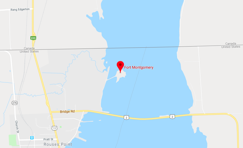
Madison wanted to preclude the British from repeat that tactic in the future. He successfully convinced Congress to appropriate up to $600,000 (about $10 million today) for the construction of a military installation — a fort — on a tiny peninsula just off the border called Island Point, as seen at the red-flagged point in the map above. The strategic value of the position is obvious — it is only accessible by land from the U.S. side, but cuts significantly into the lake, creating a pinch point in case of invasion. There was only one problem:
Island Point wasn’t in the United States.
Two years into construction, the United States and Canada re-surveyed the border, which was, by treaty, placed at the 45th Parallel in this part of the continent. That’s when they realized there was something wrong. The not-yet-complete fort was at 45.0056°N, or, as Neatorama explains, “it was accidentally built half a mile north of the Canadian border.”
Building a fort to defend against your neighbor is one thing; building a fort on your neighbor’s land, though, that’s not going to do too much for you. The United States, having discovered the error, immediately halted construction, having spent nearly half the budget at that point. Canadian scavengers, over the subsequent two and a half decades, plucked what they could from the installation they dubbed “Fort Blunder.”
And yet, the map above clearly shows two things: first, there’s a fort on Island Point (“Fort Montgomery”) and second, that fort (and Island Point) are on the U.S. side of the border. What’s going on? As Jeopardy! champ Ken Jennings explained in a Conde Nast Traveler column, a subsequent treaty in 1842 shifted things to match where both sides had previously, but erroneously, thought the border was. As part of the deal, “Britain agreed to cede Island Point to the U.S., keeping the accidentally meandering border that had led to the mix-up,” per Jennings, and starting in 1844, the United States constructed the fort they always intended to.
Bonus fact: If you want to cross into the United States from Canada, there are lots of points of entry. One of them: Alcan Border, Alaska. (Here’s a map.) Unlike most border towns, Alcan Border exists solely as a customs checkpoint. All of its 33 residents either work for the U.S. Customs and Border Patrol or are related to someone who is.
From the Archives: The Pig War: When the U.S. and Canada almost went to war over a pig.