The Google Maps Invasion

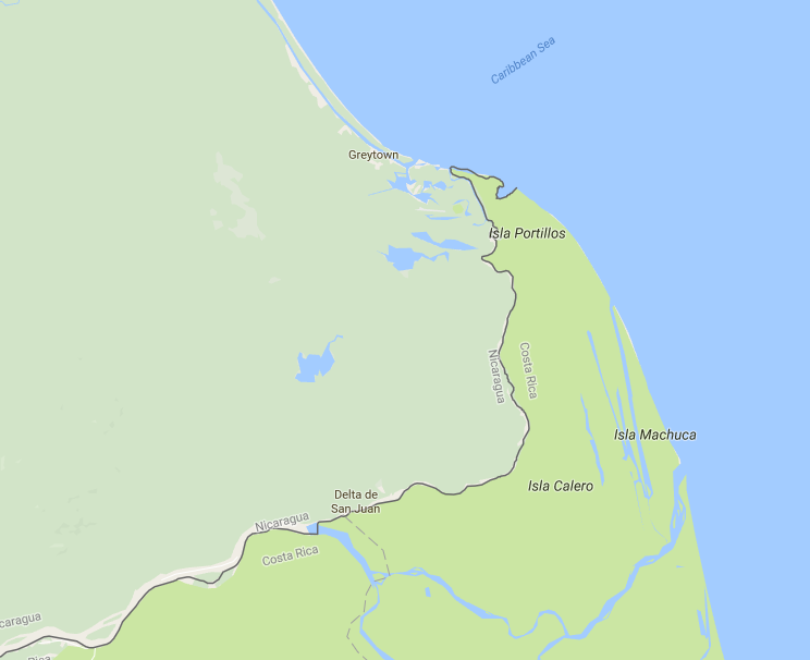
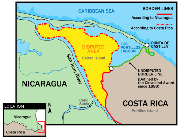
Hop over to Google Maps and scroll to the eastern shore of Nicaragua and Costa Rica — or just click here — and you’ll see the section above. Costa Rica is the darker green region to the south and extending up the coast; Nicaragua is the lighter green area. It’s pretty clear, from this map at least, that Isla Calero — known as Calero Island in English — is in Costa Rica. But that fact is in dispute. Nicaragua, relying on a border interpretation different from that of Costa Rica’s, claims sovereignty over the northern tip of the island. Below, via Wikipedia, is a map clearly outlining the claims.
There are a lot of disputed border lines around the world and, therefore, a lot disputed territories. In general, these debates are between cartographers and bureaucrats and don’t boil over into military action. The Calero Island dispute is one of these otherwise-peaceful ones — usually. But in 2010, something went wrong. And Google Maps was probably to blame.
In the fall of 2010, Nicaragua sent a small force toward the disputed area, intending to dredge an approximately 20 mile-long (33 km) stretch of the San Juan River. On its face, there was nothing nefarious about the operation — it was an engineering job and the military was best equipped to perform it. But the Costa Rican government disagreed. From Costa Rica’s perspective, the Nicaraguan dredging crew had crossed the border between the two nations; intentionally or not, Nicaragua had just invaded Costa Rica.
The Nicaraguans didn’t see it the same way. More than a century and a half earlier, the two sides entered into a treaty which sets the boundaries between the two nations. Most interpretations put the disputed area, above, under control of Costa Rica, and Costa Rica acted accordingly. Seeing the incursion of its territory, the Costa Rican government deployed 70 law enforcement agents to the area. Nicaragua responded with 50 troops of its own, and an international incident had begun.
Most of the world agreed that Costa Rica controlled the area, pursuant to the treaty linked to above. But a minority interpretation of that treaty — one favored by Nicaragua — said otherwise. And in support of that interpretation, according to Costa Rican press at the time, the commander of the Nicaraguan press cited Google Maps. For reasons unclear, it seemed that Google’s seemingly authoritative maps product roughly agreed with Nicaragua’s interpretation of the treaty. The New York Times explained: “The digital atlas had indeed placed the eastern end of the border between the countries to the south of the generally accepted line, providing Nicaragua with a territorial gain of a few square miles.” The Nicaraguan commander saw this likely error as an opportunity; if Google says it, it has to be true, right?
Thankfully, no blood was shed. The two nations resolved their dispute peacefully via international arbitration, although the process itself was contentious and, even as recently as 2016, some details were still in dispute. But the real victims of the non-war were the product managers at Google, who had to eat crow. On November 5, 2010, Google announced that “yesterday they became aware of a dispute that referenced the border between Costa Rica and Nicaragua as depicted on Google Maps. This morning, after a discussion with the data supplier for this particular border (the U.S. Department of State), we determined that there was indeed an error in the compilation of the source data, by up to 2.7 kilometers. The U.S. Department of State has provided a corrected version and we are now working to update our maps.”
Bonus fact: The Ft. Lauderdale suburb of Sunrise, Florida, is home to about 90,000 people and hosts the arena of the NHL’s Florida Panthers. But in the fall of 2010 — a few weeks before the Nicaraguan invasion of Costa Rica — Sunrise disappeared from the map. Okay, only from Google Maps. As CNN reported, “people who searched Google Maps for the city were directed instead to Sarasota, Florida — a place that, while an alphabetical cousin of Sunrise, is actually 200 miles away. No Sunrise business or addresses or phone numbers showed up. Even city hall and other public entities were strangely absent.” Google said they fixed the error, but the mayor of the city wasn’t convinced; he told CNN that “this [was] ithe third time Google has dropped his city off the digital map.” (It hasn’t happened since, though.)
From the Archives: The Middle of Nowhere: Google Maps’ map of the town that doesn’t exist (and never has.)
Related: “The Art of Illustrated Maps: A Complete Guide to Creative Mapmaking’s History, Process and Inspiration” by John Roman. Only four reviews, but all give it five stars.