The Problem with Chinese GPS
If you’re in a foreign country and try to read a map, you may find it difficult — unless your host nation’s language is the same as your home nation’s, the words are going to be different and, assuming you’re not bilingual, will require some translation. But the locations of the roads, rivers, buildings, and the like should be the same, regardless of whether the map is in English, Spanish, or Chinese, right? Language aside, Google Maps should work the same everywhere, right?
Well… no.
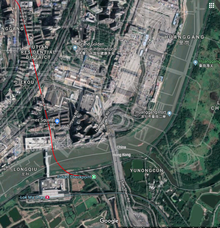
Pictured above is a map of the China/Hong Kong border via Google Maps; you can see it yourself by clicking here. The map is your standard road map overlaid upon a satellite image. As you can see, the roads — the light grey lines — don’t match up with reality. There are roundabouts which purport to be in public parks, bridges which don’t exist, and multi-lane highways which seem to be underwater. The whole thing is a big navigational mess. Go far enough into Hong Kong, though, and the problem abates.
What’s going on? The map data, basically, is being lost in translation.
The world — China aside — uses something called the World Geodetic System 1984 (“WGS-84”) as the basis for the digital maps. Virtually all the navigation tools we use online today — the maps apps on our phones, the GPS systems in our cars, the missile guidance systems in use by the military, and yes, Google Maps — all use WGS-84. China, though, goes its own way.
The Chinese use something called GCJ-02, an alternative system which the cartography world colloquially refers to it as the “Mars Coordinates” as it may as well be made for another planet. The Google Maps screenshot and link, above, shows the problem: the road map data comes from the Chinese government, which uses GCJ-02, but the satellite data is from a non-Chinese source and uses WGS-84. (As China exerts control over, and takes responsibility for mapping out the border between itself and Hong Kong, the problem bleeds into the neighboring pseudo-sovereign state.) The two data sets, effectively, are speaking different languages.
China isn’t just trying to be different, though; they’re trying to be difficult. The government has long seen map data as a matter of national security. There’s a “Surveying and Mapping Law of the People’s Republic of China” which greatly restricts who can make maps. One needs a cartography license, one which comes with many strings; if you’re creating digital map data, for example, it needs to use GCJ-02 and has to be hosted on servers within China. And this isn’t one of those anachronistic laws which go ignored and unenforced. In 2015, for example, the country announced that those who violate the law could face fines of 200,000 yuan (about $30,000 at the time) and, according to CityLab, “if the violation is deemed serious enough, [those who run afoul of the law] can even find themselves booked on criminal charges.”
So why not just make a tool which translates GCJ-02 to WGS-84? Well, there are a few, but they’re typically hard to come by and not all that reliable. Multinational corporations like Google don’t want to deploy them as it could hurt their standing with the Chinese government. And even if they did, the results wouldn’t be great. GCJ-02 isn’t just an alternative coordinate system; it’s an often unpredictable one. As Wikipedia explains, “it uses an obfuscation algorithm which adds apparently random offsets to both the latitude and longitude.” And even if you can get around those issues, it won’t matter much if you’re in China itself. If you use a mobile device there, per Travel and Leisure, “Chinese geographic regulations demand that GPS functions must either be disabled on handheld devices or they must be made to display a similar offset.”
So if you’re traveling to China, knowing Chinese may be a lot more helpful than you’d think.
Bonus fact: The GPS system used by the world (minus China) doesn’t pay for itself. The upkeep of the system runs about $900 million a year and is paid for by U.S. taxpayers. (As TIME suggests, that cost is “quite a bargain when you think about it.”)
From the Archives: Reverse Cartography: Agloe didn’t exist until someone put it on the map. Then, it did.