The Island the U.S. and Canada Both Want
If you were to look at a map of the border between the United States and Canada, you’d see thousands of miles of well-defined lines — through forests, across lakes, along mountain ridges. It’s one of the longest international boundaries in the world, and for the most part, both countries agree exactly where it is.
But there’s one exception — a tiny one.
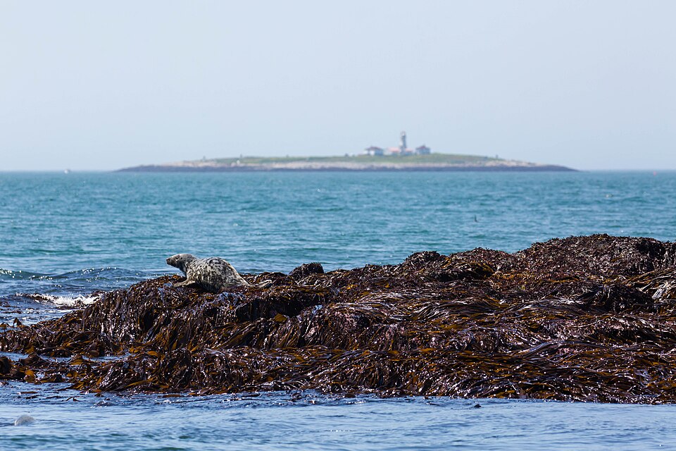
Pictured above — in the horizon — is Machias Seal Island. The island sits in the Gulf of Maine, about ten miles off the coast of Cutler, Maine, and roughly the same distance from New Brunswick’s Grand Manan Island. (Here’s a map, but you’ll need to zoom out for context.) It’s too small and remote to support a town, or even a village — there are no permanent residents in the traditional sense. What it does have is a lighthouse, a few wooden buildings, and a whole lot of puffins. No one lives there permanently, but you’ll always find someone at home — two lighthouse keepers from the Canadian Coast Guard who rotate through in month-long shifts live on the island year-round.
But despite the Canadian quasi-military presence there, Machias Seal Island isn’t unambiguously Canadian. Canada claims it as its own, of course — but so does the United States.
The dispute dates back to the Treaty of Paris in 1783, which ended the American Revolution. According to the BBC, both countries believe that treaty placed Machias Seal Island under their control. The Americans point to a clause granting the U.S. rights to any territory within twenty leagues of its coast; the Canadians cite a 1621 land grant that claimed any island within six leagues of Canadian coastline for the crown. Machias Seal Island, somewhat inconveniently, satisfies both conditions.
Canada has been more assertive in staking its claim. In 1832, the British built a lighthouse on the island, and Canadians have staffed it continuously ever since — in part, as Atlas Obscura notes, “for sovereignty purposes.” (An unclassified U.S. State Department result even points out that “despite having automated the lighthouse, the Canadian Coast Guard maintains lighthouse keepers on the island to support its claim to sovereignty.”) The United States, meanwhile, has taken a more passive approach. It briefly posted personnel on the island during World War I — at Canada’s request — but has otherwise declined to make a permanent mark.
The two countries had a chance to resolve the matter in 1984, when they submitted other boundary disputes to the International Court of Justice at The Hague. But Machias Seal Island was conspicuously left out. As The Atlantic reported, “neither side was willing to have its interests invalidated.” The island remained in limbo — a gap in the boundary line, surrounded by contested waters that local fishermen call “the grey zone.”
The reason for wanting the island isn’t its resources — there aren’t any — or a military advantage. But rather, it’s the surrounding waters — the surrounding seas, turns out, are prime lobster territory and, neither country is eager to give up access. American and Canadian fishermen work the area under a kind of informal truce, though tensions occasionally flare. “Most of the time, if you try and work with them, they will try and work with you,” one Canadian fisherman told the BBC. “But if you want to be a push and shove, you are going to be pushed and shoved back.”
For now, the island’s most consequential inhabitants remain the puffins. Thousands of Atlantic puffins, common murres, and Arctic terns nest on Machias Seal Island each summer, making it one of the largest and most diverse seabird colonies on the East Coast. It’s become a tourist destination of sorts, but only to a limited degree, in part because of the border controversy. Only a limited number of tourists per day — roughly fifteen from each country — are allowed to visit during breeding season, and they’re confined to wooden blinds so as not to disturb the birds. The lighthouse keepers, meanwhile, keep watch over both the seabirds and the sovereignty. “The birds do not care; they do not know the difference,” one keeper told the BBC of the border dispute. Neither, it seems, do the two nations — at least, not enough to settle it.
Bonus fact: Most of the U.S./Canada border runs over land, from the Pacific Ocean eastward to the Great Lakes. That land border doesn’t have a wall, but it isn’t just an invisible line on a map. As Atlas Obscura notes, it’s very visible, not by what’s there, but by what isn’t: trees. The border, known as “The Slash,” is a 20-foot wide line that runs across the border that’s been deforested — the two nations have partnered to remove the trees and keep it that way. Americans and Canadians, per Atlas Obscura, invest (collectively) about $1.4 million in tax dollars to support the upkeep.
From the Archives: The Fort That Would Have Never Worked: Another U.S./Canada border issue.