The Border Dispute That Vanished
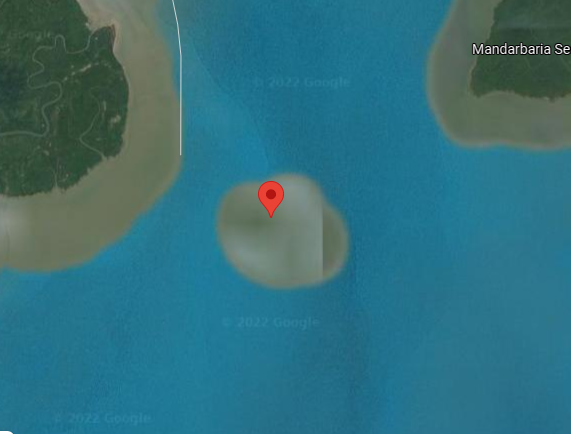
The image above is a screenshot from the satellite view of Google Maps. The white line running from top of the image, about a quarter of the way from the left edge of the screenshot, is the border between India (on the left) and Bangladesh (on the right). The red-flagged area is an island in the Bay of Bengal, and if you extend the white line straight down, the island would be on the Bangladeshi side of the border. But the white line doesn’t extend that far, and there’s a good reason why: when the border between the two nations was first established in 1947, the island above didn’t exist.
Once it did, both nations laid claim to it. India called in New Moore Island; Bangladesh called it South Talpatti. Today, it’s called neither of those two things — and neither nation gets to claim it.
The issue of the island began in November of 1970. Early that month, a cyclone formed in the Bay of Bengal, and the aftermath was horrible. The storm, now called the Bhola cyclone, made landfall and claimed more than half a million lives while causing hundreds of millions of dollars in damages. And the storm was so strong that it shifted the silt on the floor of the bay, particularly in areas near where the Ganges River delta and that of its tributaries. That, in turn, impacted the water flow in the area, and in or around 1971, someone noticed a tiny land mass had emerged about two kilometers (1.2 miles) from the mouth of the Hariabhanga River. (Here’s a map.) The island, while tiny, was economically important — the Bay of Bengal is generally believed to have a good amount of oil and natural gas under its floor, and both nations would like exclusive access to it.
That, thankfully, was the only major military action over the island, but it didn’t resolve anything. Over the subsequent years, both countries petitioned the United Nations to intervene. But before the UN took action, something unexpected happened:
The island disappeared.
As the Guardian reported in 2010, climate change beat the nations to a resolution. Rising sea levels engulfed the island, submerging it likely permanently. As one oceanographer told the press outlet, “what these two countries could not achieve from years of talking has been resolved by global warming.” And that’s a bigger concern for Bangladesh than control over some parts of the Bay of Bengal. The disappearance of their island is likely to be the start, not the end, of the damage: per the Guardian, “officials estimate 18% of Bangladesh’s coastal area will be underwater and 20 million people will be displaced if sea levels rise one meter by 2050 as projected by some climate models.”
But until then, control over the coastal regions of the Bay of Bengal are still important to both nations, so — despite the disappearance of the island — the countries required a resolution of the border dispute. And in 2014, the UN’s Permanent Court of Arbitration finally did rule on the larger issue of the Hariabhanga River delta, ruling primarily in Bangladesh’s favor.
Bonus fact: Some Bangladeshi poultry farmers have adjusted to climate change by simply changing livestock. Chickens don’t do well during cyclones — they can’t fly away for cover, and when their coops get flooded, they’re doomed. In 2013, the British Red Cross partnered with the Bangladesh Red Crescent to help address the situation, and in part, tackled flooding and cyclones by helping farmers switch from chicken to ducks. Per the Red Cross, “because ducks can swim and fly, they can hold their own better during a cyclone. So the project helped people switch to raising ducks and now families have duck meat and eggs to eat or sell.”
From the Archives: The Most Isolated People in the World: A story about a small island in the Bay of Bengal.