The “I’m Not In Washington” Defense
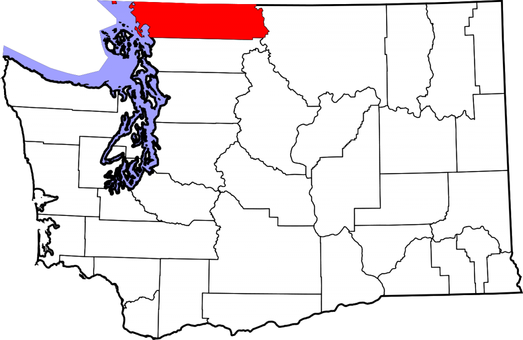
The red area in the map above is Whatcom County, Washington, and as you can see, it is in the northwest of the state, bordering Canada. Its northern border is also the state border and the international border, and — the little red dot hanging out to the west, in the water aside — it appears to be an uninterrupted straight line. And it kind of is. The Oregon Treaty, an agreement signed in 1846 between the United States and Great Britain (of which at the time Canada was a part) set that border at the 49th Parallel. When the State of Washington was incorporated and admitted to the union in 1889, its state constitution adopted that same border. That is, Article XXIV Section 1 on the Washington constitution sets the border in this area at “west along said forty-ninth parallel of north latitude.”
Seems clear, simple, and straightforward, right? The Washington Supreme Court does not agree.
The problem began in 1996, a century and a half after the signing of the Oregon Treaty. Three Americans — Helen Norman, Kevin Belen, and Laura Lee Stradwick — were stopped by U.S. border patrol just south of the 49th Parallel. That normally wouldn’t be an issue except for the fact that Norman and Stradwich were carrying some illegal drugs on them, and Belen for some reason had a stolen credit card in his possession. The three were taken into custody and ultimately charged — and convicted — in Washington’s state courts.
But they had an interesting defense. They claimed they weren’t actually in the state of Washington. In fact, they argued, they weren’t in any state at all.
While today, we can measure the location of the 49th Parallel with accuracy and precision, the same wasn’t nearly as true in 1846. When the U.S. and Great Britain surveyed the border, they did so with a bunch of errors. As the New York Times notes, the border doesn’t follow the 49th Parallel nearly as closely as you’d think. “Marked by a 20-foot strip of clear-cut forest, the border may seem straight as a ruler. But as it zigzags from the first to the last of the 912 boundary monuments erected by the original surveyors, it deviates from the 49th parallel by up to several hundred feet.” And the border patrol station where Norman, Belen, and Stradwick were arrested? It was in one of those deviations. Per the Associated Press, the three were searched and arrested “north of the 49th parallel, but south of the official [U.S./Canada] border.”
That shouldn’t be a big deal, but let’s re-read that line from the state constitution again: the state’s border run “west along said forty-ninth parallel of north latitude.” Norman et al were arrested north of that line, and, under the constitutional definition of where the state ends, that’s outside of Washington state. It’s ridiculous, yes, but the plain language of the constitution is clear, and the law can sometimes give ridiculous results. So they appealed — all the way to the state Supreme Court. Their argument, per the Court’s website? “Defendants maintain that because the state constitution defines Washington’s northern boundary in relevant part as the 49th parallel, the State does not have jurisdiction to prosecute them for crimes committed south of the international border between the United States and Canada, but north of the 49th parallel as currently located.”
Perhaps not wanting to create “a nebulous strip of territory along the border that was part of the United States, but not part of Washington,” in the words of the AP, the Court ruled against the defendants. (Per the decision, “the political and conceptual location of the international and state borders was the same when Washington was admitted as a state, and remains so.”) But don’t write off their case as entirely frivolous. One of the nine members of the Court, Justice Richard Sanders, dissented, arguing that “this case is easier than pi. The 49th parallel can be located to the decimal. If that term is ambiguous, the language of law is no more than sand shaped into castles at the arbitrary whim of he (or she) who wears the black gown.”
For Norman et al, winning over one of those Justices wasn’t enough, though. When the Court handed down its decision in 2002, the three were still in prison, with no further chance of a reversal.
Bonus fact: That little red dot in the northwest of map above, separated from the rest of the county by water? That’s Point Roberts, Washington. It’s one of a few enclaves which are part of the United States but are inaccessible by land from the rest of the nation; you need to cut through Canada to get there. In normal times, that’s not a big deal — the United States and Canada understand the oddity of the border and make accommodations for those living and visiting there. But the coronavirus pandemic has caused some unique problems; the U.S./Canada border is closed to help stop the spread of the virus. As a result, per High Country News, “most visits are prohibited. Residents of Point Roberts can cross the border only to work, pick up prescriptions or go to a doctor’s appointment in the mainland U.S., and they’re not allowed to stop in Canada at all during the trip. The only other way to reach the mainland is by private boat, or the twice-weekly $135 flight to Bellingham, Washington.”
From the Archives: No Man’s Land: Welcome to Bir Tawil, the piece of land no country wants.