Signs From Above
Before 1979, Iran was under the control of the Shah and had relatively peaceful relations with Israel. Iran Air’s headquarters was built in that calmer, friendlier time, and the lead architects on the design were, in fact, Israeli.
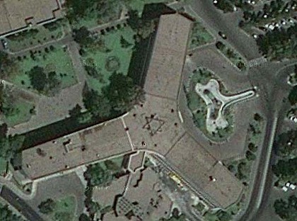
Fast forward a few decades. Iran and Israel are, in no way, friendly, and the world has given us Google Maps, replete with satellite view. So a small, possibly innocent/accidental marking of the building’s history — hidden on its roof — is now in full view: a Star of David, pictured above. (See it in Google Maps here.) Iran, upon finding it, was not amused — and is currently investigation how to remove the mark from the building.
This isn’t the first time Google Maps’ eagle eye has caused controversy. In 2007, map-watchers noticed that a Naval building in Coronado, California resembled a swastika when viewed from above. A small controversy erupted, and the Navy has since decided to do something it. To date, they’ve taken minor steps to try and obfuscate the shape, mostly by adding trees and bushes around the building. (Strangely, the Google team seems to have also taken steps to help, as the Google Maps satellite view of the building changes angles when you view it, instead taking a 45 degree angle approach.)
Other discoveries? A man-made, man-shaped lake near Sao Paolo, Brazil, and this absolutely incredible raised-earth sculpture of Sultan the Pit Pony in Wales.
Bonus fact: In World War II, Japan had an interesting method for reading maps at night. No, not flashlights. Bio-luminescent organisms, pictured here. They glow blue when disturbed, allowing for reading at night — batteries not required.
From the Archives: Flying Signs: Attaching a banner to an airplane isn’t as easy as you’d think.
Related: Above New York, a collection of photos from above New York. (Clever title!). 11 reviews, 4.9 average.
Leave a comment